Drainage Management (AQA A Level Geography)

Revision Note

Test Yourself
Jacque Cartwright

Expertise

Geography Content Creator

Issues of Catchment Management

  • Catchment management is an holistic way of looking at a whole river catchment, its interaction between water and land and how best to manage and improve drainage
  • The aim is to minimise flooding, drought, water pollution, channel erosion and improve ecosystems that rely on the river
  • Decisions are made by local authorities and private engineers, usually without consultation with local residents, which generates conflict and resentment
  • Catchment management schemes are disruptive and expensive
  • Ecological balance is disturbed through increased water temperatures and waste water discharge
  • Other issues include:
    • Concentrated water pollution and spread of viruses
    • Decreased water flow in dry periods impact aquatic ecosystems
    • Increased flooding and erosion
  • Management methods include:
    • Soft engineering - using knowledge of river basin processes to work with nature
    • Hard engineering - building structures to 'push back' against nature

Comparison of Soft and Hard Engineering Approaches to Urban Drainage Management

Soft Engineering Hard Engineering
Afforestation increases interception and reduces throughflow, along with surface runoff. EVT removes water that would eventually end up in the river channel. Afforestation reduces flood risk and water pollution Dams, floodwalls and reservoirs are built to prevent flooding and ensure a regular supply of water
Floodplain zoning - restriction on building on certain areas of a floodplain  River straightening increases the flow of water by increasing the gradient of a river's channel and removing natural meanders (bends)
Riverbank conservation to reduce lateral bank erosion and collapse through planting to stabilise banks and reduce silting downstream

Levees - natural ones can be increased in height to increase bankfull capacity 

Embankments can be built or increased using concrete or sustainable materials (usually dredged from channel)

River restoration aims to restore the river channel to its original course by removing and reversing past management strategies Channelisation adds a liner to a straightened river channel (usually concrete) to reduce friction which aims to improve flow rate and therefore, reduce silting
Restoring natural wetlands on floodplains Diversion spillways also called flood relief channels bypass the main river's channel during periods of high flood risk. They can also be a permanent feature which act as a wetland, and improve the local environment

For - overall a cheaper method of management compared to hard engineering and can improve the local environment

Against - planning restrictions limit building of new homes and businesses and difficult to implement in already urbanised areas

For - prevents flooding of homes and businesses, thereby reducing costs of repairs and loss of revenue.

Against - very expensive to build and maintain. They alter wildlife habitats and prevent aquatic migration. They affect river flow downstream - increased silting or flooding. 

SUDS

  • SuDS stands for Sustainable Drainage Systems and aims to mimic natural drainage regimes within the built environment, thereby reducing flooding, improving water quality and the value of the environment to people and biodiversity
  • SuDS achieve this through:
    • Storing runoff and releasing it slowly
    • Collecting and re-using surface water at source
    • Allowing water to infiltrate into the ground 
    • Decrease transport of surface water flow rates
    • Filtering out pollutants
    • Allowing sediments to settle out by controlling the flow of the water
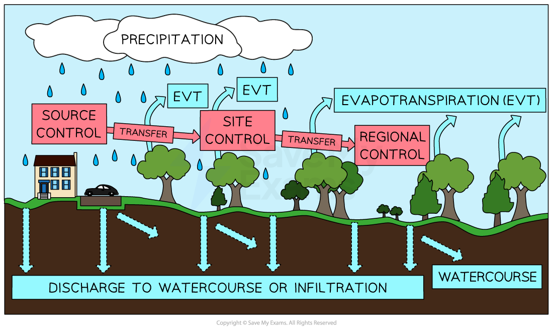
  • SuDS uses a sequence of techniques that together form a management train or sub-catchments
  • Natural drainage techniques are used in stages to change the characteristics of the flow and quality of the runoff
  • The management train starts with prevention - reducing impermeable areas and measures for reducing pollution
  • It progresses through local source controls to larger downstream site controls and finally regional controls
  • Runoff doesn't need to go through all the stages in the management train, it can flow straight to a site control
  • Managing and returning runoff to the natural drainage system near to source as soon as possible is preferable 
  • If water can't be managed locally, it is slowly transferred elsewhere - the water might need further treatment or there is too much for the system to deal with - the excess flows are then routed off site

suds-management-train

Image showing management train pathway of SuDS

  • As surface water flows through the system, flow velocity is controlled and pollutants are removed
  • Source control methods include:
    • Interception methods such as diverting roof guttering for re-use or storage (e.g. for irrigation) or green roofs to increase evapotranspiration
    • Using pre-treatment steps, such as vegetated swales or filter trenches, which remove pollutants from surface water before discharge to watercourses or aquifers
    • Delaying discharge through retention systems of ponds, wetlands etc. 
    • Retention systems that delay the discharge of surface water to watercourses by providing storage within ponds,
    • Infiltration trenches and soakaways, mimic natural recharge, which allows surface water to soak into the ground
  • SuDS impact on the flow of water during a storm event:
    • Surface water flows through swales and filter trenches removing pollutants
    • Peak river discharge is slowed and reduced through:
      • Capture and storage of water for re-use
      • Storage in ponds and wetlands
      • Infiltration of water to the ground through infiltration basins  and soakaways
      • Water quality is improved and peak river discharge is decreased 
         

Techniques, Purpose and Benefits of SuDS

Technique Purpose Benefit
Swales Wide shallow drainage channels, usually dry and can be landscaped as recreational spaces Slows down surface runoff
Green roofs Grass and wildflower habitats on roofs with minimal runoff to gutters Has insulating properties and increases evapotranspiration (EVT)
Infiltration basins  Vegetated depressions that are are dry except during heavy rainfall Stores surface runoff and allows infiltration into ground
Rain gardens Shallow depressions planted with flowers and shrubs Creates a green space for recreation and increases EVT
Detention basins Excavated basins for temporary storage of water during flood events Allows for infiltration and groundwater recharge
Bioretention basins Gravel and sand filtration layers beneath reed beds collect and filter dirty water Wetland spaces provide wildlife habitats
Permeable surfaces Porous block paving, concrete and road surfaces  Reduces build up of surface runoff and flooding. Helps to reduce water pollution
Retention ponds Open areas of permanent shallow water, but are also designed to temporary store excess water from rainfall.  Can cater for all storms and are good at filtering urban pollutants

You've read 0 of your 0 free revision notes

Get unlimited access

to absolutely everything:

  • Downloadable PDFs
  • Unlimited Revision Notes
  • Topic Questions
  • Past Papers
  • Model Answers
  • Videos (Maths and Science)

Join the 100,000+ Students that ❤️ Save My Exams

the (exam) results speak for themselves:

Did this page help you?

Jacque Cartwright

Author: Jacque Cartwright

Jacque graduated from the Open University with a BSc in Environmental Science and Geography before doing her PGCE with the University of St David’s, Swansea. Teaching is her passion and has taught across a wide range of specifications – GCSE/IGCSE and IB but particularly loves teaching the A-level Geography. For the last 5 years Jacque has been teaching online for international schools, and she knows what is needed to pass those pesky geography exams.