
Causes of Aridity
- Aridity is affected by:
- The global circulation of air
- Topography/rainshadow effect
- Cold ocean currents
- Prevailing winds
- Continentality
- The global circulation of air:
- Hot arid and semi-arid deserts are found in the tropics and subtropics due to two large convective cells called Hadley Cells that control the air circulating between the equator and the tropics in the northern and southern hemispheres
- The area where the dry air descends is a zone of high pressure known as the sub-tropical high

Diagram showing the impact of the descending limbs of the Hadley Cells on the atmospheric pressure system of hot deserts
- Note that as the cool, dense, dry air descends, it is being warmed by high levels of insolation

- Hot air rises and cooler air sinks through the process of convection
- The irregular heating of Earth’s surface creates various pressure cells, each generating different weather patterns
- The movement of air within each cell is roughly circular and moves surplus heat from equatorial regions to other parts the Earth

- Winds blow outwards from the sub-tropical high-pressure area, leaving the air dry and preventing moisture from being brought in by winds
- This results in low precipitation rates
Topography/rainshadow effect
- Also called the orographic effect and prevents moisture-laden air from arriving
- Air is forced to rise over mountains, which then cools, condenses and forms clouds and rain
- This leaves only dry air to carry on over the crest of the mountain, creating a dry area on the other side called a rain shadow
- For example, the Atacama desert is due to the Andes acting as a barrier, and stopping the rain-bearing, south-east trade winds from Argentina and the Atlantic
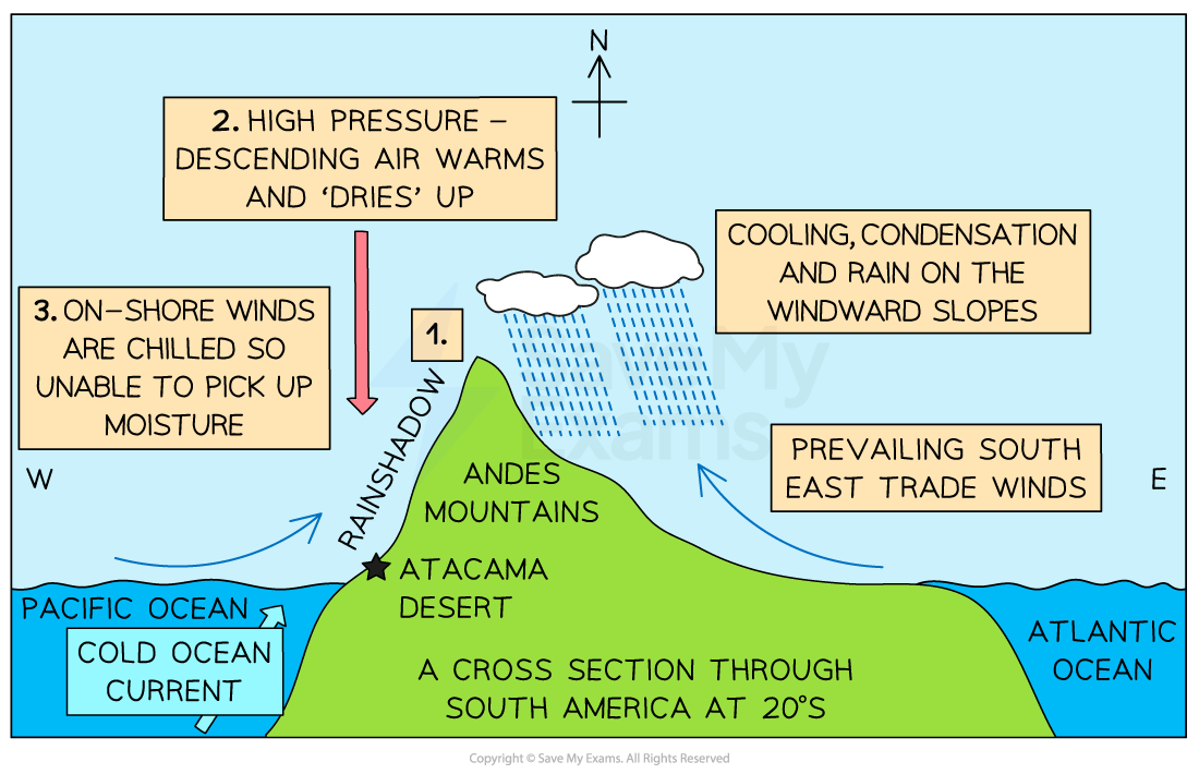
Image showing the orographic effect helping to form the Atacama Desert, Chile
Cold ocean currents
-
- Cool air above ocean currents holds less moisture, these currents travel close to land
- These bring cool dense air that displaces warmer air over the land
- Once this cool air hits the land it heats up and evaporates any moisture in it, leaving a coastal fog, which brings some moisture
- Air that travels further inland is dry and warm
- Ocean currents are a major factor in increasing the aridity in the Namib, Atacama and Sonoran deserts
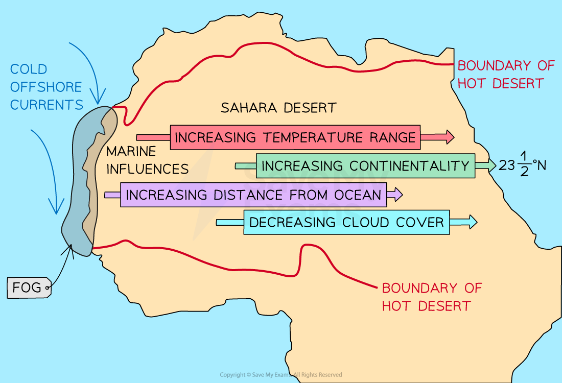
Image showing how cold ocean currents do not bring much moisture to the interior of continents
Prevailing winds
- In many hot, arid areas, prevailing winds blow from land to sea and carry little moisture
- E.g.NE trade winds from N. Africa to the Atlantic influence the Sahara desert
- Winds are strong and gusty, influencing landforms
- At the centre of the high-pressure cell, winds are calm but at the edges of the system, there are the trade winds and westerlies meaning it can be very calm or very windy in a desert
Continentality
- Many deserts are in the middle of continents far away from rain-bearing winds
- Large distance means that offshore winds can't carry moisture for that length of time, so most is lost before it reaches inland areas
- The only wind that reaches, is dry and warm
Reasons for location
- Hot semi-arid deserts are found between the equator and hot deserts, they fringe hot deserts and experience seasonal rainfall in summer
- The reason is that the rain-bearing Hadley cells migrate with the movement of the sun between the Tropic of Cancer and Capricorn called the Intertropical Convergence Zone (ITCZ)
- The ITCZ is a low-pressure zone that normally lies near the geographic equator and divides the global air circulation patterns into two mirror images to the north and south of the equator
- The ITCZ forms where the Northeast Trade Winds meet the Southeast Trade Winds just north of the earth's equator
- The arid and semi-arid regions of Africa (Sahara and Sahel) lie north approx. 10°N, near the northern limit of the ITCZ, and receive one rainy season with very little precipitation (due to evaporation)

Image showing the ITCZ migration and seasonal rain in the Kalahari Desert
Exam Tip
If you are asked to explain why the Atacama Desert is arid, it is important to remember that there are three reasons.
- The Atacama lies on the wrong side of the Andes with regard to prevailing winds. At 20 degrees south the southeast trade winds carry moist air from the Atlantic, but as the winds are forced to rise across the Andes, the air is cooled, condensed and rains on... the 'wrong' side of the Andes! This means that the Atacama lies in a rainshadow.
- The second reason is related to air pressure. Air generally rises at the equator because of the maximum heating of the earth's surface. Once in the upper atmosphere, high-level winds carry the air toward the poles. The air gradually cools and beings to sink to earth between 20 and 25 degrees south (exactly where the Atacama lies), creating high pressure. Descending air begins to warm, and any moisture evaporates into water vapour, so there is no rain.
- Finally, the Atacama lies close to cold ocean current flows. The Pacific Ocean is colder at this latitude, therefore, on-shore winds are chilled as they cross the currents and don't have enough warmth to pick up moisture from the ocean surface, keeping the winds dry.

format('truetype')%3Bfont-weight%3Anormal%3Bfont-style%3Anormal%3B%7D%3C%2Fstyle%3E%3C%2Fdefs%3E%3Ctext%20font-family%3D%22Times%20New%20Roman%22%20font-size%3D%2236%22%20font-weight%3D%22bold%22%20text-anchor%3D%22middle%22%20x%3D%2211.5%22%20y%3D%2233%22%3EP%3C%2Ftext%3E%3Ctext%20font-family%3D%22math1da8af8fff63a0c7c6de70abde8%22%20font-size%3D%2232%22%20font-weight%3D%22bold%22%20text-anchor%3D%22middle%22%20x%3D%2251.5%22%20y%3D%2233%22%3E%3D%3C%2Ftext%3E%3Ctext%20font-family%3D%22Times%20New%20Roman%22%20font-size%3D%2236%22%20font-weight%3D%22bold%22%20text-anchor%3D%22middle%22%20x%3D%2281.5%22%20y%3D%2233%22%3EE%3C%2Ftext%3E%3Ctext%20font-family%3D%22math1da8af8fff63a0c7c6de70abde8%22%20font-size%3D%2232%22%20font-weight%3D%22bold%22%20text-anchor%3D%22middle%22%20x%3D%22110.5%22%20y%3D%2233%22%3E%2B%3C%2Ftext%3E%3Ctext%20font-family%3D%22Times%20New%20Roman%22%20font-size%3D%2236%22%20font-weight%3D%22bold%22%20text-anchor%3D%22middle%22%20x%3D%22141.5%22%20y%3D%2233%22%3EO%3C%2Ftext%3E%3Ctext%20font-family%3D%22math1da8af8fff63a0c7c6de70abde8%22%20font-size%3D%2232%22%20font-weight%3D%22bold%22%20text-anchor%3D%22middle%22%20x%3D%22171.5%22%20y%3D%2233%22%3E%26%23xB1%3B%3C%2Ftext%3E%3Ctext%20font-family%3D%22Times%20New%20Roman%22%20font-size%3D%2236%22%20font-weight%3D%22bold%22%20text-anchor%3D%22middle%22%20x%3D%22198.5%22%20y%3D%2233%22%3ES%3C%2Ftext%3E%3C%2Fsvg%3E)

