Past & Present Desert Landscapes (AQA A Level Geography)

Revision Note

Test Yourself
Jacque Cartwright

Expertise

Geography Content Creator

Desert Development Over Time

  • Each desert landscape is unique due to past and present interactions of rocks and processes operating on them
  • Wind and water action are the most important processes, although weathering, mass movement and vegetation also play a role
  • Processes operating in desert systems can create new landforms or change existing landforms
  • This means that desert landscapes change over time
    • Changes in inputs change the landscape, e.g. an increase in sediment input may increase deposition
    • Over time the landscape would then change from an erosional landscape to one dominated by landforms of deposition
  • Landforms of past processes can undergo further change
    • A wadi formed by past river flow will be further eroded by the episodic sheet and channel flooding
  • Hot desert landscapes are, therefore, made of a mixture of characteristics and landforms that reflect different periods of time
    • Canyons formed when the climate was wetter (interglacial period ≈8000 years ago) and present-day landforms such as pedestals
  • Changes occur over a range of spatial and temporal (time) scales
    • Changes can be short and episodic such as flash floods transporting material in wadis
    • Too long and gradual, such as wind eroding rock over thousands of years to form a pedestal rock
  • Changes to desert landscapes occur slower than in other regions because many weathering and erosional processes need water
    • The Atacama Desert can go years without rain, therefore, processes operate slowly and episodically there

Basin and range

  • This topography develops in landscapes where past tectonic faulting has occurred through extension, deformation and sedimentation
  • The horizontal extension of crustal plates stretches the area and faults appear
  • Vertical deformation (displacement) takes place along these fault lines
  • Creating a rising 'range' of mountains and a dropped valley 'basin' 
  • Mountains continue to erode, with streams carrying sediment down to the valley floor

simplified-basin-and-range

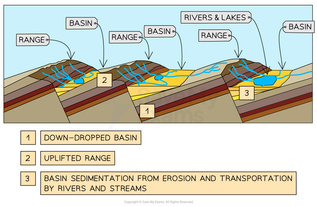
Image showing the simplified formation of a basin and range landscape 

Case study

  • The Western US Basin and Range extends to the Rocky Mountains, South Central and Southwestern states
  • It includes all of Nevada, south-eastern California and Oregon, with high mountain ranges running mostly north-south with alternating low valleys
  • 20 million years ago, the crust along the Basin and Range stretched, thinned, and faulted into approximately 400 mountain blocks
  • Upward pressure from the mantle, lifted some blocks, forming stretched peaks, whilst leaving the lower blocks to form down-dropped valleys
  • Boundaries between the basins and ranges are acute (sharp) because the faults are straight between them
  • Also, many of the faults are still active

basin-and-range-of-sierra-nevada

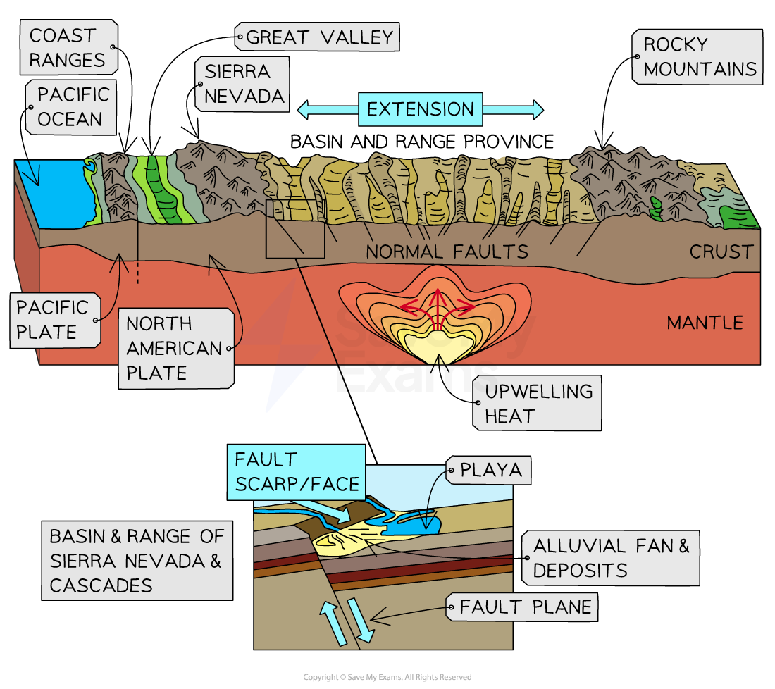
Image showing the formation of the basin and range of the Sierra Mountains and Cascades, USA 

Desert Extent & Distribution of Change

Pleistocene pluvials

  • The Pleistocene is the geological epoch that lasted from about 2,588,000 to 11,700 years ago, spanning the world's most recent period of repeated glaciation
  • The end of the Pleistocene corresponds with the end of the last glacial period and also with the end of the Palaeolithic age used in archaeology
  • A pluvial refers to the characteristic of rainfall
  • The evolution of arid and semi-arid landforms is often affected by events that occurred long ago
  • Many current desert landforms, began to develop during pluvial periods several thousand years ago
  • The sporadic activity takes place with sudden downpours/deluges where a lot of erosional activity takes place in limited locations such as wadis, but this would not be enough to create the range of water-eroded features
  • Therefore, pluvial periods in the Pleistocene and beyond are seen as the likely period for most landform formation of deserts
  • Some do argue that wind erosion and deposition are still actively giving rise to depressions, yardangs, zeugens and dune systems
  • But, the scale suggests that water action and past weathering have been a significant factor
    • Wadis and integrated valley systems are unlikely to have formed under present conditions
    • Piedmont zone landforms show evidence of having been formed by intense water action
    • Dunes are the reworking of vast sand seas, a result of alluvial deposition in a wetter climate

The Changes to Hot Desert Climate Over Time

5000 years ago to the present day

Over Asia and Africa, the monsoon rains began to lessen, and so began arid conditions. 3000 years ago, conditions were similar to today. 

About 8000 years ago 

During this interglacial period, conditions were warmer and more humid. Forests thrived and were widespread in warm and wet conditions. Aridity fell dramatically, with many of the present-day deserts being grasslands. 

Last glacial maximum

20,000 years ago

During the last glacial maximum, aridity was widespread, with cold deserts in the north. In the south, deserts existed in similar locations to the present day but were more extensive.

You've read 0 of your 0 free revision notes

Get unlimited access

to absolutely everything:

  • Downloadable PDFs
  • Unlimited Revision Notes
  • Topic Questions
  • Past Papers
  • Model Answers
  • Videos (Maths and Science)

Join the 100,000+ Students that ❤️ Save My Exams

the (exam) results speak for themselves:

Did this page help you?

Jacque Cartwright

Author: Jacque Cartwright

Jacque graduated from the Open University with a BSc in Environmental Science and Geography before doing her PGCE with the University of St David’s, Swansea. Teaching is her passion and has taught across a wide range of specifications – GCSE/IGCSE and IB but particularly loves teaching the A-level Geography. For the last 5 years Jacque has been teaching online for international schools, and she knows what is needed to pass those pesky geography exams.