Periglacial Processes (Edexcel A Level Geography)

Revision Note

Jacque Cartwright

Expertise

Geography Content Creator

Past & Present Periglacial Landscapes

  • A periglacial landscape is characterised by permanently frozen ground or permafrost and is defined as:

‘An area where soil and rock has not risen above 0°C for at least 2 consecutive years'

  • Approximately 25% of the Earth's surface is considered periglacial, but during the Pleistocene epoch it covered as much as 45% of the surface, extending into the lower latitudes of southern England and Europe
  • Permafrost is not controlled by soil moisture and ice does not need to be present
  • Permafrost is prevalent in Siberia (up to 1500m deep) and Northern Canada (depths of 700m) 
  • Most permafrost water stays frozen as ground ice

Comparison of Glacial and Periglacial Areas

Action
Periglacial Glacial
Altered by ice Within the ground Above ground
Landforms created through Freeze/thaw weathering and mass movement Erosion and deposition
Found Outer margins of cold environments, especially in the northern hemisphere around the Arctic; high altitudes and continental interiors High altitudes and latitudes

    • Areas of unfrozen ground within the permafrost are known as talik
    • Talik can be:
      • Open - a small area of unfrozen ground exposed to the surface
      • Through - a large mass of unfrozen ground beneath a small open area
      • Closed - unfrozen ground surrounded by permafrost
    • Permafrost can be subdivided into:
      • Continuous - large, unbroken stretches of permafrost, that reach depths of up to 1,500 meters – largest areas are located in Canada, Alaska and Siberia
      • Discontinuous - mostly permafrost, with some small, localised unfrozen ground (talik)
      • Sporadic - where small patches of frozen ground occur in talik (unfrozen ground)
      • Isolated  - there are random pockets of permafrost within the talik 
      • Subsea - or offshore permafrost is frozen ground within seabed sediments. Originally formed on land and was subsequently submerged as sea levels rose after the last Ice Age

periglacial-permafrost

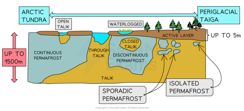
Image showing types of permafrost found in periglacial areas

  • Seasonal melting at the surface produces the active layer  of between 2cm to 5m in depth 
  • However, any meltwater cannot drain through the impermeable permafrost below and sits on the surface as thaw lakes
  • Thaw lakes are common in these poorly drained areas and as the water continues to absorb solar radiation, the depth and size of these lakes increase in size
  • In the past, the area of permafrost was more extensive and permafrost covered most of southern England, giving it a tundra landscape 
  • The periglacial landscape is littered with angular rocks across its surface
  • Quickly weathered through freeze-thaw processes, these areas are called felsenmeer, meaning 'field of rocks' in German

Periglacial Processes

  • Processes within periglacial environments are due to frost action and include:
    • Ground ice
    • Solifluction
    • Nivation
    • Frost contraction and ice wedges
    • Frost heave
    • Freeze-thaw
  • Ground ice
    • The most common form of ground ice is pore ice
    • It develops in the pore spaces between soil and rock particles, where meltwater has accumulated and frozen
    • Needle ice are thin slivers of ice and can be several cm long
    • Found mostly in moist soil where temperatures drop below freezing at night
    • Needle ice helps with loosening material for erosion and moving soil particles in soil creep
  • Frost contraction and ice wedging
    • As temperatures drop, the active layer freezes and contracts
    • Crack begin to form in the permafrost as a result
    • When the active layer thaws, meltwater will fill the cracks
    • The cold of the permafrost freezes the water in the crack, forming ice-wedges
    • Continued melting and thawing can enlarge the crack to sizes of 3m wide and 10m deep

periglacial-ice-wedging

Ice wedge formation over time

  • Nivation
    • A blanket term for active processes that occur at the edges of snow patches 
    • The processes include physical and chemical weathering that occur underneath patches of snow
    • Fluctuating temperatures and meltwater promote chemical weathering and freeze-thaw action 
    • Weathered material is transported with the summer meltwater
    • Repeated cycles of melting, freezing and transportation forms nivation hollows
    • Saturated debris (due to summer meltwater), destabilises the slope and slumping may occur 

nivation-process

Diagram showing the process of nivation and the formation of hollows

  • Frost heave
    • Frost heave occurs when soil particles or small stones are forced to the surface by ground ice
    • Freezing occurs from the surface downwards, which helps ice crystals to form either within the soil pores or as ice needles
    • As the ground ice expands, these crystals force soil and stones to the surface
  • Freeze-thaw
    • The action of freeze-thaw weathering (frost shattering) results in rough, angular broken rocks 
    • At the foot of a slope, these rocks are known as scree
    • Periglacial regions are also characterised by blockfields or felsenmeer, caused through quick freeze-thaw action of temperatures of between -5° to -14°C

process-of-freeze-thaw-weathering

  • Solifluction is a form of mass movement
  • There are two types of solifluction:
    • Fast 
    • Slow
  • Fast 
    • When an active layer on a slope becomes heavily waterlogged due to melting, gravity acts to pull it downhill
    • This flow of material is called solifluction and produces characteristic lobes on the sides of the slopes
    • The steeper the slope, the faster and further the material will travel, and the larger the lobe will be
    • Movement can be up to 10 cm/yr
  • Slow 
    • Also known as solifluction or soil/frost creep occurs when water in the soil expands as it freezes
    • This expansion forces soil particles to rise perpendicular to the ground (frost heave)
    • As the ground thaws, the particles are dropped vertically downwards (due to gravity)
    • With each repeated cycle, soil particles gradually 'creep' downslope at a rate of a few cm/yr
  • Wind erosion 
    • Periglacial regions often have strong winds and these continue to erode rock debris produced by glaciers and ice caps

  • Meltwater erosion
    • Meltwater is seasonal, plentiful and freely flows from a tunnel at the base of the glacier's snout or across the surface of the glacier and into moulins or crevasses 

Exam Tip

Always remember that these processes are not one off occurrences. They are cyclical and take number of years to complete. 

You've read 0 of your 0 free revision notes

Get unlimited access

to absolutely everything:

  • Downloadable PDFs
  • Unlimited Revision Notes
  • Topic Questions
  • Past Papers
  • Model Answers
  • Videos (Maths and Science)

Join the 100,000+ Students that ❤️ Save My Exams

the (exam) results speak for themselves:

Did this page help you?

Jacque Cartwright

Author: Jacque Cartwright

Jacque graduated from the Open University with a BSc in Environmental Science and Geography before doing her PGCE with the University of St David’s, Swansea. Teaching is her passion and has taught across a wide range of specifications – GCSE/IGCSE and IB but particularly loves teaching the A-level Geography. For the last 5 years Jacque has been teaching online for international schools, and she knows what is needed to pass those pesky geography exams.